

Latest Version
Version
3.14.2
3.14.2
Update
July 11, 2025
July 11, 2025
Developer
Soar.Earth Ltd
Soar.Earth Ltd
Categories
Catalogs
Catalogs
Platforms
Android
Android
Downloads
0
0
License
Free
Free
Package Name
au.com.mappt
au.com.mappt
Report
Report a Problem
Report a Problem
More About Mappt: Mobile Mapping & GIS
*** PLEASE NOTE: You can use Mappt for the first 120 minutes of each session for free. However, after this time is up, you will need to purchase a monthly license from US$29 to unlock full functionality. For more information about features and licensing tiers, please visit www.mappt.com.au/pricing.***
- - - - - -
Mappt is a powerful mobile and GIS (Geographic Information System) data collection app that allows users to create, edit, store and share location-based data using your Android device.
Mappt is used in industries spanning from environmental and agriculture, to mining and local government in over 130 countries worldwide.
Mappt can export your mapping data into popular GIS formats compatible with common GIS applications including ArcGIS and QGIS.
In addition, the user friendly interface provides easy to use features that even those new to field data collection will master in minutes, including:
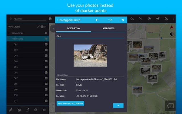
- Add geotagged photos to give your important data a far more visual element than just a marker point
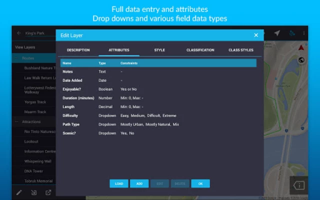
- Create or edit drop down forms for faster data collection
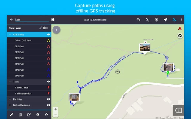
- Allows Offline GPS tracking
- On-screen annotation tools to draw, add text and create shapes over your data
- Read and download a full suite of WMS/WFS & WMTS datasets
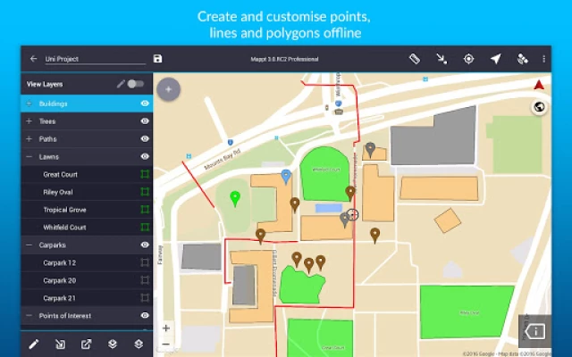
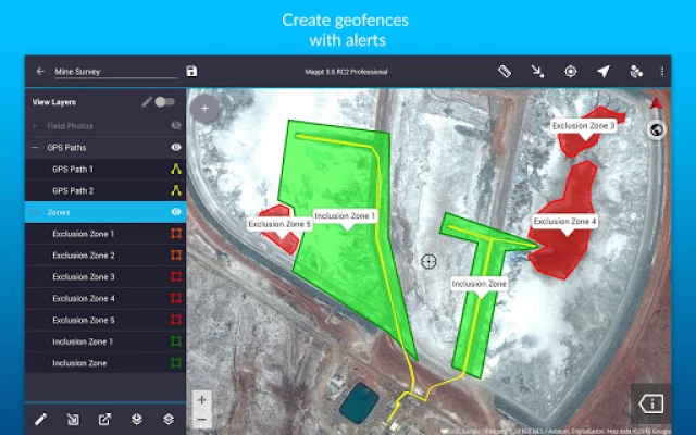
- Points, polygons and polylines and add attributes including geofencing capabilities
- Overlay coordinate grids see the exact distance between areas
- Street view mode with on-screen annotations available
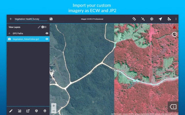
- Import unlimited sized satellite, aerial, geological, topographic, elevation and other types of imagery in ECW and JP2 format
- Import and export popular GIS formats such as Shapefiles, JP2 and KML/KMZ (compatible with both WGS84 and GDA 2020)
- Share your data between popular cloud storage tools such as Google Drive
Users have chosen Mappt for a range of in-field tasks including:
- Field mapping
- Land surveying
- Vegetation management
- Forestry planning
- Environmental management
- Incident reporting
- Mine management
- Farm mapping
- Utility mapping
- Government planning
- Asset management
Leave internet worries, bulky equipment and inaccurate data in the past, and experience a more efficient future of data collection with Mappt.
Mappt is a powerful mobile and GIS (Geographic Information System) data collection app that allows users to create, edit, store and share location-based data using your Android device.
Mappt is used in industries spanning from environmental and agriculture, to mining and local government in over 130 countries worldwide.
Mappt can export your mapping data into popular GIS formats compatible with common GIS applications including ArcGIS and QGIS.
In addition, the user friendly interface provides easy to use features that even those new to field data collection will master in minutes, including:
- Add geotagged photos to give your important data a far more visual element than just a marker point
- Create or edit drop down forms for faster data collection
- Allows Offline GPS tracking
- On-screen annotation tools to draw, add text and create shapes over your data
- Read and download a full suite of WMS/WFS & WMTS datasets
- Points, polygons and polylines and add attributes including geofencing capabilities
- Overlay coordinate grids see the exact distance between areas
- Street view mode with on-screen annotations available
- Import unlimited sized satellite, aerial, geological, topographic, elevation and other types of imagery in ECW and JP2 format
- Import and export popular GIS formats such as Shapefiles, JP2 and KML/KMZ (compatible with both WGS84 and GDA 2020)
- Share your data between popular cloud storage tools such as Google Drive
Users have chosen Mappt for a range of in-field tasks including:
- Field mapping
- Land surveying
- Vegetation management
- Forestry planning
- Environmental management
- Incident reporting
- Mine management
- Farm mapping
- Utility mapping
- Government planning
- Asset management
Leave internet worries, bulky equipment and inaccurate data in the past, and experience a more efficient future of data collection with Mappt.
Rate the App
Add Comment & Review
User Reviews
Based on 0 reviews
No reviews added yet.
Comments will not be approved to be posted if they are SPAM, abusive, off-topic, use profanity, contain a personal attack, or promote hate of any kind.


More »

Popular Apps

Peacock TV: Stream TV & MoviesPeacock TV LLC

Mr.Billion: Idle Rich TycoonIDSIGames

WPS Office-PDF,Word,Sheet,PPTWPS SOFTWARE PTE. LTD.

Ludo King®Gametion

TCG Card Store Simulator 3DBlingames
Statastic Basketball TrackerStatastic Solutions FlexCo

FatsomaFatsoma Android

RealVNC Viewer: Remote DesktopRealVNC Limited

Truth or Dare Game - OweeOwee

3D Chess GameA Trillion Games Ltd
More »
Editor's Choice

Grim Soul: Dark Survival RPGBrickworks Games Ltd

Craft of Survival - Gladiators101XP LIMITED

Last Shelter: SurvivalLong Tech Network Limited

Dawn of Zombies: Survival GameRoyal Ark

Merge Survival : WastelandStickyHands Inc.

AoD Vikings: Valhalla GameRoboBot Studio

Viking Clan: RagnarokKano Games

Vikings: War of ClansPlarium LLC

Asphalt 9: LegendsGameloft SE

Modern Tanks: War Tank GamesXDEVS LTD